wip
BALANCING Reactions:
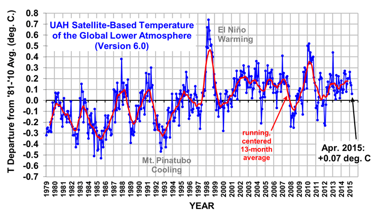
Unexplored Possible Climate Balancing Mechanism
Human health/welfare, Food production, Sea levels, Animal welfare.
Glaciers and Ice volume: Perhaps more temperature indicators than meaningful end results but both would be correct.
http://wattsupwiththat.com/2012/03/01/nasa-and-multi-year-arctic-ice-and-historical-context/
1939 : All Of The World’s Glaciers In Retreat (http://www.real-science.com/1939-worlds-glaciers-retreat)
http://chiefio.wordpress.com/2011/06/22/about-that-sea-level/
Crack in the Antarctic!
Sea levels: land “falling”, ice melting – in ocean, no change – from land increased volume – heat induced expansion – previous history –
Chiefio post (above) -extract:
Well, EcoTretas took a look at the island sea level data. Not only did he find some islands going up while others nearby were going down, he found that the data presented had been neatly “pruned” for “best effect”…
http://ecotretas.blogspot.com/2011/05/micronesia-sea-level.html
Looks like sea level is going up in Pohnpei and Kapingamarangi, but not in Yap. Why might that be? Checking the data and graph in detail, one sees that Yap has all the recent data, but Pohnpei and Kapingamarangi lack data, especially Kapingamarangi, which doesn’t show the decline in 2010. Careful analysis of the graphs show that the highest levels in recent years have similar values in the 80s and 90s…
[…]
But more data is being concealed. If one grabs the daily data for Yap, and plots all those daily measurements into a graph, you’ll get the one below:
[…]
There is data since 1969! While there seems to be a growing trend since the beginning of the nineties, the truth is that the highest values since mid-2002 are lower than the higher values in the mid seventies, and lower than several peaks in 1984, 1998, 1999, 2000, 2001 and 2002. The lowest value in 2010 is lower than any value from 1969 till 1980!
Hit the link for the whole article and the graphs. It’s worth it.
He also has a related posting where he finds that the data get “adjusted” but only one way:
http://ecotretas.blogspot.com/2011/05/rate-of-sea-level-rise-going-down.html
The first entry should be the relevant file. If you click on it, you’ll get the most recent data. If you click on Google’s cache entry (probably available for only some days; keep a copy…), you’ll get the older data (#version_2010_rel5). Importing into a worksheet and plotting a linear regression is quite easy. Getting a graph for the evolution of the linear regression values over time is also not that difficult, using the SLOPE() function. The results are the following two graphs:


Notice that the rate of rise has gone up, due to the Colorado correction, but is going down. And it’s going down faster! When they last plotted the data, the value for cycle 2010.7415 was 2.956158611, just enough to round it to 3.0, when considering one decimal place, as they do. Now, they have figured out the trick to leave the rate of rise above 3.1, at least for some months…
So just what sea level will be used as the measured level for the suit? Who knows. But I’m sure they can find some mangrove swamp somewhere that is having subsidence and put a lot of photos on a bench.
Strong El Niño Could Bring Increased Sea Levels, Storm Surges To US East Coast
 |
Coastal communities along the U.S. East Coast may be at risk to higher sea levels accompanied by more destructive storm surges in future El Niño years, according to a new study by NOAA. The study was prompted by an unusual number of destructive storm surges along the East Coast during the 2009-2010 El Niño winter.
Jul 15, 2011 – 10:51:21 AM
22/7/11 from The Australian:http://www.theaustralian.com.au/national-affairs/sea-level-rises-are-slowing-tidal-gauge-records-show/story-fn59niix-1226099350056
Climate change researcher Howard Brady, at Macquarie University, said yesterday the recent research meant sea levels rises accepted by the CSIRO were “already dead in the water as having no sound basis in probability”.
Tisdale on the new “hide the decline” version of ocean heat content data
Matt Ridley says The one trend that has been worse than expected – Arctic sea ice – is plausibly explained by black carbon (soot), not carbon dioxide.
(from WUWT http://wattsupwiththat.com/2013/01/28/matt-ridley-a-lukewarmers-ten-tests/#more-78324 )
I would suggest that it is the intrusion of warm Atlantic and Pacific waters that have fostered the the rapid melting of Arctic sea. In the Antarctic sea ice has grown more than predicted. There the Antarctic Circumpolar Current prevents direct intrusions of warmer water and sea ice extends ~uniformly beyond the Antarctic Circle. The Antarctic ice is mostly thinner annual ice and the summer melt back is far greater than the Arctic, yet still the sea ice is expanding.
In contrast, even when the Hudson Bay or Bering Sea are frozen despite lying south of the Arctic Circle, deep inside the Arctic Circle the warm water from the Atlantic causes the Barents Sea to be largely open water. Moorings have shown that there has been an increased volume in warm water from the Atlantic entering the Arctic. Likewise during the 2007 melt there was more warm water entering from the Pacific. Because Atlantic water is so salty despite being much warmer it sinks below the surface of the Arctic water . The Pacific water is also warmer but less salty. Those subsurface waters have enough heat to melt all the Arctic ice several times over if brought to the surface.
Several studies have shown the Icelandic Low and Aleutian Low modulate how much warm water enters the Arctic. Furthermore studies have shown it was cold winds, not warmth from above that removed layers of thick multiyear Arctic ice. With the loss of insulating sea ice, the winds and ocean surface were reconnected and that allowed greater mixing of warmer subsurface waters causing ice to melt from below. Studies in the Bering Strait showed that even when the flow of intruding warm water slowed and cooled, surface temperatures in the Arctic Ocean near the Beaifort Sea continued to warm due to this mixing.
Climate models have failed to correctly simulate the oscillations that drive these warm water intrusions. Thus the same models that predicted the Antarctic ice should be melting from above, also failed to predict how rapidly the Arctic ice could melt from below.
Antarctic ice – more accurate estimates
http://wattsupwiththat.com/2011/08/09/quote-of-the-week-death-of-the-arctic-death-spiral/
http://wp.me/P7y4l-5Kc More ice wuwt 25/5/2012
U-tube info on cooling/ice age.http://www.youtube.com/watch?v=1inm9YF6akM&feature=related
It wasn’t CO2: Global sea levels started rising before 1800
Australian sea-levels respond to CO2 by slowing down…
NASA notes sea level is falling in press release – but calls it a “Pothole on Road to Higher Seas”
http://scienceandpublicpolicy.org/reprint/the_great_sealevel_humbug.html
Early Winter in Switzerland
Ocean “acidification”
JoNova hosts a chemistry ‘lesson’ – The chemistry of ocean pH and “acidification”
FOOD ASPECTS:
http://www.worldclimatereport.com/index.php/2011/11/21/the-future-of-grapes/#more-515 Higher yields!
New Study Indicates Low CO2 Emission Levels Could Be Cause of Extreme Climate Change & Civilization’s Death
Do Increasing Temperatures Lower Crop Yields?